Pont-Tunnel Louis-Hippolyte-La Fontaine – Location History Facts
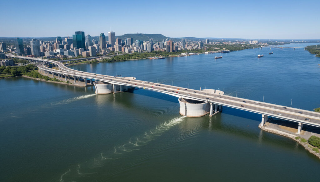
The Pont-Tunnel Louis-Hippolyte-La Fontaine stands as Canada’s longest bridge-tunnel, carrying Autoroute 25 beneath the Saint Lawrence River to connect Montreal with Longueuil. This 1.8-kilometre engineering landmark serves as a critical artery for Quebec’s transportation network, handling approximately 120,000 vehicles daily while currently undergoing the largest refurbishment in its history.
Opened in 1967 on the eve of Expo 67, the structure represents a pivotal moment in Quebec infrastructure development. Its immersed tube construction method placed prefabricated concrete sections 24 metres below the river’s surface, avoiding the visual impact of a traditional suspension bridge on Montreal’s skyline. Today, the tunnel faces significant modernization challenges, with renovation costs ballooning from an initial $1.2 billion to over $2.1 billion as work extends into 2025.
Named after the 19th-century reformer Louis-Hippolyte La Fontaine, the crossing remains essential for east-end Montreal traffic despite capacity constraints and ongoing construction-related disruptions.
What is the Pont-Tunnel Louis-Hippolyte-La Fontaine?
Key Facts
- Canada’s longest bridge-tunnel and one of the world’s largest prestressed concrete structures
- Immersed tube tunnel section measures 1,391 metres with seven prefabricated concrete segments
- Deepest point sits 24 metres below the water surface beneath the Saint Lawrence Seaway shipping channel
- Original construction cost $75 million CAD with 60% federal funding
- Current refurbishment budget ranges between $1.4–$2.1 billion
- Traffic composition includes approximately 13% commercial trucks
- Geographic coordinates: 45°34′46″N 73°28′46″W
| Specification | Details |
|---|---|
| Total Structure Length | 1.8 km (1.1 mi) |
| Tunnel Section Length | 1,391 m (4,563 ft) |
| Immersion Depth | 4.6–6.1 m below riverbed (15–20 ft) |
| Deepest Point Below Water | 24 m (79 ft) |
| Segment Dimensions | 110 m × 37 m × 8 m (360 × 121 × 26 ft) |
| Segment Weight | 32,000 tonnes each |
| Original Construction Cost | $75 million (1967) |
| Current Refurbishment Cost | $2.1 billion (2022 estimate) |
| Daily Vehicle Capacity | ~120,000 vehicles |
| Highway Designation | Autoroute 25 |
Where is the Louis-Hippolyte-La Fontaine Tunnel located?
The structure spans the Saint Lawrence River at the eastern end of Montreal Island, specifically connecting the Mercier–Hochelaga-Maisonneuve borough to the city of Longueuil on the south shore. The route passes via Île Charron, creating a continuous highway link that avoids the congestion of downtown crossings.
Precise geographic coordinates place the tunnel entrance at 45°34′46″N latitude and 73°28′46″W longitude. Quebec Ministry of Transport records designate this positioning downstream from the Saint Lawrence Seaway, allowing the immersed tube to pass beneath the main shipping channel without disrupting maritime traffic. The UPS Canada Phone Number – Official Service Numbers and Hours provides logistical support information for commercial traffic utilizing this corridor.
As the primary east-end crossing for Highway 25, the tunnel offers an alternative to the busier Champlain and Jacques-Cartier bridges further west. Its location proved strategically significant during the 1960s expansion of the Trans-Canada Highway, creating a direct route from the Ontario border to Rivière-du-Loup without forcing traffic through Montreal’s central districts.
History and construction of the tunnel
Origins and Planning
Construction commenced in 1963 as part of the Trans-Canada Highway expansion. Engineering records indicate authorities deliberately selected an immersed tube design rather than a suspension bridge to preserve Montreal’s skyline and minimize neighborhood disruption. Workers demolished a church in Longue-Pointe and expropriated 300 families in 1964 to clear the approach corridors.
Engineering Method
Workers dug a trench in the riverbed and sank seven prefabricated concrete sections 4.6 to 6.1 metres below the surface. Each segment measures 110 metres long, 37 metres wide, and 8 metres high, weighing approximately 32,000 tonnes. The tunnel descends to 24 metres beneath the water surface at its deepest point, passing under the main shipping channel.
The project faced significant social costs during construction. Beyond the 300 families displaced in 1964, the demolition of historic structures in Longue-Pointe marked a transformative period in Montreal’s urban development, reflecting the era’s priority toward automobile infrastructure over existing communities.
Opening and Recognition
The tunnel opened on March 11, 1967, just months before Expo 67. Archival accounts record that Quebec Premier Daniel Johnson inaugurated the facility, praising it as a monument to Quebec engineering innovation. Montreal Mayor Jean Drapeau attended the ceremony, marking the occasion as a significant achievement for provincial infrastructure.
Current status and traffic updates
Major Refurbishment Program
A comprehensive $1.2–$2.1 billion refurbishment began in 2020 intended to extend the structure’s operational life by 40 years. Technical documentation indicates the work addresses decades of poor prior maintenance, requiring full rehabilitation while maintaining partial traffic flow.
Completion deadlines have shifted repeatedly since project inception. Initially scheduled for 2024, authorities postponed the finish date to 2025, with costs escalating from $1.2 billion to $2.1 billion by 2022. Recent assessments suggest additional delays may extend the timeline further, though the tunnel remains operational throughout construction.
Traffic Conditions
The tunnel currently handles approximately 120,000 vehicles daily, including a 13% commercial truck share. Traffic monitoring data confirms that construction has reduced capacity from three lanes in some sections, creating congestion during peak hours. Despite these limitations, the crossing remains fully operational as a critical link between Montreal and the south shore.
Current rehabilitation work includes specialized sealing systems designed to withstand high water pressure and structural movement. These technical upgrades address the unique challenges of maintaining an immersed tube structure that has processed over five decades of continuous traffic.
Project Timeline and Impact
Infrastructure tracking lists the refurbishment among Canada’s most significant current investments. Work progresses while the tunnel maintains its essential function, representing a complex engineering challenge of renovating a vital artery without closing it completely.
Construction and renovation timeline
- 1963: Construction begins on the Trans-Canada Highway extension, utilizing immersed tube technology to avoid skyline disruption
- 1964: Demolition of Longue-Pointe church and expropriation of 300 families to clear approach corridors
- March 11, 1967: Official opening ceremony with Quebec Premier Daniel Johnson and Montreal Mayor Jean Drapeau
- 2020: Launch of major refurbishment project, initially budgeted at $1.2 billion with 2024 completion target
- 2022: Cost revision to $2.1 billion announced, with completion deadline extended to 2025
- 2023–2025: Ongoing rehabilitation work continues with lane restrictions while maintaining operational status
What facts are confirmed versus uncertain?
Established Information
- Total length of 1.8 km with 1,391 m tunnel section
- Opened March 11, 1967 at cost of $75 million
- Handles approximately 120,000 vehicles daily
- Refurbishment costs reached $2.1 billion by 2022
- Located at coordinates 45°34′46″N 73°28′46″W
- Seven concrete segments each weighing 32,000 tonnes
Information Remaining Unclear
- Precise final completion date for current refurbishment
- Exact duration of specific lane restrictions during peak construction phases
- Final total cost projections given ongoing delays
- Long-term traffic capacity plans post-renovation
- Specific alternative routing recommendations during full closures (if any)
Why does this crossing matter to Montreal?
The Pont-Tunnel Louis-Hippolyte-La Fontaine represents more than concrete and steel; it functions as an economic lifeline for Quebec’s largest metropolitan area. By providing the primary east-end connection between Montreal and Longueuil, the structure diverts significant commercial and commuter traffic away from the more congested central bridges, distributing regional movement patterns more evenly across the island.
Named for Louis-Hippolyte La Fontaine, the first head of a responsible government in Canada, the crossing carries symbolic weight alongside its practical function. The Half and Half Cream – Definition Nutrition Uses Substitutes offers insight into local Quebec products transported daily through this corridor to markets across the province.
The tunnel’s immersed tube design, chosen specifically to protect Montreal’s visual character, set a precedent for subsequent infrastructure projects prioritizing urban aesthetics alongside engineering requirements. Its current renovation represents the largest investment in maintaining this critical link since its original construction nearly sixty years ago.
Official statements and historical records
“This tunnel stands as a monument to Quebec engineering innovation.”
— Daniel Johnson, Premier of Quebec, March 11, 1967
Contemporary accounts from the 1967 inauguration emphasize the pride associated with completing the project ahead of Expo 67. Federal contribution covered 60% of the original $75 million price tag, reflecting Ottawa’s commitment to completing the Trans-Canada Highway system through Quebec.
Key points for travelers and commuters
The Pont-Tunnel Louis-Hippolyte-La Fontaine remains Quebec’s most significant east-end river crossing despite current construction limitations. Travelers should anticipate reduced lane availability and potential delays through 2025 as refurbishment work addresses structural maintenance deferred over previous decades. The tunnel maintains 24-hour operation, serving as the only direct Autoroute 25 link between Montreal and the south shore communities.
Frequently asked questions
How deep is the Louis-Hippolyte-La Fontaine Tunnel under the water?
The tunnel passes 24 metres (79 feet) beneath the water surface at its deepest point, positioned beneath the main shipping channel of the Saint Lawrence Seaway.
Is the tunnel currently closed for construction?
No full closures have been implemented. The tunnel remains partially open during refurbishment, though lane reductions from three lanes cause congestion during peak periods.
Why was an immersed tube chosen instead of a bridge?
Engineers selected the immersed tube method to avoid constructing a large bridge that would impact Montreal’s skyline and require extensive neighborhood demolition beyond the 300 families already expropriated.
How much did the original construction cost compared to current renovations?
The 1967 opening cost $75 million CAD (60% federally funded), while current refurbishment costs have escalated to $2.1 billion as of 2022 estimates.
What percentage of traffic consists of commercial trucks?
Commercial trucks comprise approximately 13% of the roughly 120,000 daily vehicles using the crossing.
When will the current renovation project finish?
Official targets have shifted from 2024 to 2025, though uncertainty remains regarding the final completion date given ongoing technical challenges and cost overruns.
Who was Louis-Hippolyte La Fontaine?
Louis-Hippolyte La Fontaine was a 19th-century Canadian reformer who became the first head of a responsible government in Canada, representing democratic advancement and provincial autonomy.
More related posts
 What Doe GPT Stand For? Generative Pre-trained Tran former
 Pharmaprix Flyer Next Week: Circulaire Semaine Prochaine
 Nina Ghaibi: Career, Nationality, and Marriage to Félix
 Statistiques de la Liga – 2024/25 Standings, Top Scorers
 Mitch Marner Trade: Why He Left the Leafs for Vegas
 FIFA Club World Cup Players 2025: Rosters & Missing Teams
 Chef Anna Olson: Biography, Husband, Children, and YouTube
 Max Verstappen: Age, Child, Net Worth & Salary Guide